
Longest Day, Longest Drive
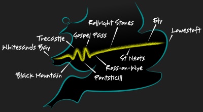
Our challenge was to drive from the most easterly point of England to the most westerly point of Wales, starting at sunrise and finishing at sunset on the longest day of the year. A race against the sun from Lowestoft to Whitesands Bay, with time off for lunch. No snooze-control roads, just 17 hours and fourteen minutes in an Ariel Nomad. Try the film here.
We started in North Beach car park, and yes I know Ness Point is a few feet further east but it's cramped and not the place to begin anything. So we got to the car park a little before 4:30 on a perfect morning when the North Sea was calm to the horizon. We watched the bright orange sun edge into view, then turned and headed for the Atlantic. After escaping the Lowestoft suburbs on the A146 and A143 as far as Harleston, we struck off across country. Suffolk and Norfolk are the definition of flat and the roads, with nothing to deflect them, are ruler straight. In the early morning we made good progress towards Thetford, apart from a satnav glitch that tried to lock us into an endless circle of left turns.
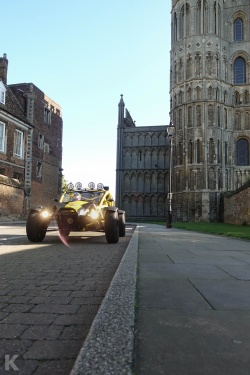
Foiling the satnav's evil plan, we skirted Thetford and cut through the heart of Thetford Forest to Brandon and across the fens to Ely along Highbridge Gravel Drove (alas no gravel), Newman's Drove and Farthing Drove, good straights joined by even better right-angles that triggered the Nomad's g-force amplification circuits. The sight lines were good and the sky was big and at some point Ely cathedral grew out of the flatness. We could have gone through Cambridge but it doesn't like cars any more and in Ely we could drive right past the cathedral, which looked fine in the early light. From Ely we hacked across more fenland, keeping to the back roads as commuters began to clog the main ones. This was the last section of long straights before the land became less cooperative and bent the roads to its own shape, and Haddenham to Earith to Swavesey didn't disappoint. The nature of the road shapes the nature of the driver, and here was a gung-ho attitude to acceleration that said "don't worry, it's a long way to the next corner."
Our next stop was the A14 services at Swavesey, entirely lacking in charm but at least it had a Cost-U-Bucks (TM) open for a second breakfast at this still unreasonable hour, and was a good place to wait for the worst of the commuter traffic to clear. Then on to St Neots, convenient for crossing the Great Ouse but even more convenient for the B645, known as Spa, that leads in fast and sweeping curves to Higham Ferrers. This is a great road with only two drawbacks - first its popularity with bikers, and second the police trying to catch the bikers. And third, there's too high a chance of being stuck behind a lorry, so we turned off at Great Staughton and took a quieter but equally good route. The first section to Pertenhall is fine, and Swineshead Road from there to Yelden and on to Higham Park is excellent. A little further on we tipped our hats to the Santa Pod Raceway, then drove through the centre of Wollaston and continued across Northamptonshire towards Towcester.
South of Towcester we skirted the race track at Silverstone and were soon into the Cotswolds where the hills got a little taller, the villages much more golden and the celebrities thicker. I mean denser. I mean there are just too many of them. We, however, were not celeb hunting but on our way to the Rollright Stones, a neolithic stone circle, because this was the summer solstice and we wanted to go a little pagan. Rollright is Stonehenge's tiny brother - the stones came up to my knees - and as it was the solstice there was quite a crowd, must have been at least fifteen (while 15000 were at Stonehenge). We sat by the stones, ate lunch, and contemplated the symmetry of being there in the middle of the longest day.
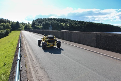
We pressed on through Stow-on-the-Wold, known for its horse fairs, then to Ross-on-Wye, which is pretty and where we forgave the traffic jam because the Nomad was getting some love from passers-by, and then to the Welsh border and up Gospel pass, the highest road in Wales. The Brecon Beacons have too many excellent roads to choose from, a dilemma we solved with a zigzag starting at the Black Mountains (plural) and ending with the Black Mountain (singular) which is not in the Black Mountains range. Really. In between we went south to Pontsticill reservoir where we could drive along the dam wall, which was fun, and then back north on the A470. I did think of taking Sarn Helen, a very Nomadic climb through stunning scenery, but the quick A470 was a happy contrast with the narrow, bumpy, twisty roads we'd just driven. This isn't a route for the wide and low, and the Nomad proved again that it's the perfect machine for country roads.
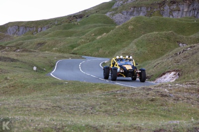
We didn't follow the A470 all the way to Brecon but cut across to Trecastle then down to the gorgeous A4069 Black Mountain Road. I prefer it north to south, taking the best bends uphill, particularly that hairpin. There's a car park just past it where people stop to admire the view but a good fellow with the right priorities turned his car around to watch us instead. It's so good that I confess I drove it again, and then again. The Nomad loves a good hill climb. Still, the sun was sinking relentlessly lower and we had half of Wales to cross.
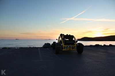
Next was Carmarthen and Haverford West on the quickish A40 before we touched the sea at Newgale and Solva and then turned back inland, past St Davids to begin the final run to Whitesands. But the closer we got the slower we went because the sun was now at eye level. The Nomad does not have sun visors, which is good for its looks but not so good for driving west at sunset. Sunglasses are not enough and even my stylish and practical cap couldn't protect me so there were times I was creeping along trying to spot stray walkers and cyclists. Yet, just as it seemed we would miss the moment, we were down the last hill and rolling to a stop by the sea. We'd driven for 17 hours from east to west, racing the sun across the flat openness of the broads and the fens, through that bit in the middle, then over the gentle Cotswold hills and the glorious Welsh mountains. Definately time for a paddle.

|
Lowestoft to Whitesands Bay route for GPS |