
Circles of Skye
It's said that in Skye the weather changes by the minute, and this was true from the first day when within a minute the rain would change from vertical to horizontal and back. Then the rain stopped and there was a perfect little rainbow sitting over the loch in front of the house while otters bobbed beneath it. Then, in case it all seemed too perfect, the midges came out.
A Skye road typically takes you somewhere and then stops because there's nowhere else to go but into the sea. There are a few good circular routes, however, and these are our top three, with a film here.
The Popular
The first and most obvious circuit runs from Portree up the east coast, past the Old Man of Storr, the Mealt Falls, the Quirang and the Fairy Glen. It's an easy drive, the roads are mostly good, and you'll know where to stop for each view by the crowds already there. It is mathematically proven that if a Skye car park holds n cars, 2n will try to fit into it, and having failed will park on the verge.

|
The Popular route for GPS |
We started in Portree on the A855, hugging the edge of Loch Leathan with The Old Man of Storr in the distance. A little further on is Mealt Falls, hard to see without a boat or a drone, and then Staffin where we turned left onto the Quirang Pass. This road is, on its own, worth the trip to Skye. Single track and a little rough, it climbs gradually towards the bulk of the Quirang where there's a gorgeous little switchback hugging a cliff. Or it is gorgeous when it's empty, but you must be very early or very lucky to have a clear run.
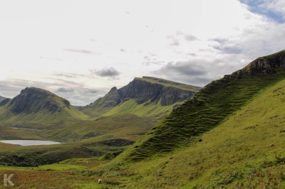
There's a car park at the top, but it will be full so if you want to take a walk it's better to park at the bottom by the Sartle cemetery and take the path diagonally up. And it is worth the climb because, no matter how stunning the Quirang looks from the road, there is so much more. A good policy is to drive to the top, find there's no room and drive back down, go for a walk, then have a second drive up because the road that runs on across the peninsular to Uig is single track but quite flat, open and free-flowing.
The descent into Uig is steep and includes a hairpin guaranteed to embarrass anyone with a large turning circle (that would be me). A little south of the town we turned left to the fairy glen, not strictly on the circuit but too weird to pass up. The small rounded hills of the glen are, obviously, home to the fairies; the cairns and rock-spirals are the work of visitors who seem to think the place isn't magical enough without their help. The sticky-up rock in the middle of it all, Castle Ewan, looks unclimbable from the front but from the back was an easy scramble.
South of the fairy glen the sea gradually gets closer from the right, changing from Uig Bay to the brilliantly named Loch Snizort. The road back to Portree is smooth and sweeping and anywhere else it would be known for the landscape, but this is Skye so it's just another dramatically mountainous skyline.
The Not Quite
The second circuit covers the middle and eastern part of the island. I thought we'd found an epic route but it didn't quite work out.
|
|
The Not Quite route for GPS |
Starting in Portree again, we could have gone back up the A87 to the junction with the A850, but we went on the B885, single track, decent surface, lots of twists climbing out of the town, then a quick drop into a valley. At the fork don't take the left marked "impassable in winter" - I know it's a crime not to take an impassable road, but this wasn't winter. We turned right and went alongside the River Snizort until it joins the A850 to Dunvegan. The guidebook option here is to go on to the lighthouse at Neist Point, but we went right for an excursion out to Claigan (green on the map). The road is classic Skye and eventually it just stops. We stopped too and, walking across a field and through a hedge, got to the Coral Beach. There is no coral here, only maerl seaweed that breaks into white fragments when it dies but nonetheless it's a lovely sweeping bay and the water is an unexpected blue, a little bit of West Indies with a Scottish climate. The bay isn't deep and if the tide is very low you can wade to Lampay Island. There weren't many people when we arrived, but the car park, true to local principles, is very small and by the time we left it was gridlocked. As with everywhere else in Skye, if there's something you particularly want to see, go early.
Further along the A863 there's a nice diversion to Ebost where we shared the bay with no one but some cows. We sat by them looking out to sea until an angry woman appeared brandishing a walking stick. Supposing we were the cause of her irritation (perhaps we were too loud or too yellow) I complimented her on the cows, which was a mistake because it was them she was cross with - they were on the wrong half of the beach and she was driving them back to the correct half. As there was only a stream to distinguish the cow-half from the not-cow-half she might have been expecting too much of them.
The A863 is a classic of sweeping bends and stunning views and soon we got to Bracadale where, if we'd stayed longer at the beach, we might have turned left and followed the B885 back to Portree. But with time to spare we carried on and just past Drynoch is the turning to Carbost. Here, pushed against the bay, is the Talisker whisky distillery. Just past the distillery the road turns sharp left but at the following right we went straight on, climbing over a ridge then dropping alongside the Eynort river (blue on the map). As we got near the coast we turned into a forest and found a gravel track. From the map it looked like this would lead back onto tarmac and run past the Fairy Pools making it the best route on the island. After a while, though, a locked gate killed the dream and we had to turn back, the disappointment leavened by a little well behaved gravel fun.
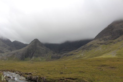
With our circuit broken we retraced our steps back to Carbost and along to the Fairy Pools (yellow on the map). It's very popular but the further you walk the quieter it gets. Eventually we returned to the car, turned around and reached Sligachan with its pretty, though always crowded, bridge that is photogenically positioned against the Cuillin mountains, and then to Portree.
The Southern
|
|
The Southern route for GPS |
If you take the ferry to Skye you dock at Armadale in the south and very likely take the A851 north to Broadford and Portree. On the way you pass a turning to Kilbeg that you should definately take.
It starts well with a sign saying it's unsuitable for caravans and, if you've just spent a day following a convoy these sensible, practical globules of fat along some of the finest driving roads in the country, that sign will bring instant joy. The road heads west, climbing gradually until it clears a ridge called the Hill of the Eagle, and drops to Loch Dughaill with views to the Black Cuillins or possibly the Red Cuillins, or perhaps the island of Soay - it's hard to tell them apart. There's space for one car to stop at the west end of the loch, which we did, until the midges forced us on. From there to the coast at Tarskavaig the road is a perfect rollercoaster of sudden drops and smooth bumps. We had the bay to ourselves so we loitered and fooled around on the lovely beach. Leaving the bay we followed another rollercoaster to Tokavaig which doesn't have the sand of Tarskavaig, but it does have Dunscaith castle. It's small and ruined and might be mistaken for a rock, but legend says that a thousand years ago it was home to a woman called The Shadow who trained mythic heroes in martial arts. The only way in was across the bridge, which is just ten feet long but missing the bit you walk on. Undaunted, we shuffled along the lip of the bridge wall, gained entry and raised our flag.
From the castle the road snakes its way upwards until the trees thin out and the view expands towards the eastern shore where we rejoined the A851 just opposite Loch nan Dubhrachan. This is, apparently, home to a kelpie, a water horse that can transform into human shape to trap its victims. This particular kelpie was last seen in 1870 and the loch was dredged in an attempt to catch it. Somehow it escaped, but the local children had the day off school and much whisky was shared so no one minded.
The Fourth of Three
Going north out of Broadford I spotted a road clinging to the edge of the headland and checking the map it seemed to go around the coast and connect back to the A87, making it half of a loop that, even if it would be a little short, we had to try. It turned out to be interesting but perhaps not suitable for everyone.
|
|
The Fourth of Three route for GPS |
The start was good. Over a bridge more functional than pretty, a right hand bend up a long straight climb then over the top and some bends down to a second bridge, this one a two arch gem, just as pretty as Sligachan and no one else in sight. From the bridge the road curved on along the headland, about half way up the steep slope. The further we went, the rougher the road became, disintegrating tarmac turning to potholes. Past a fish farm, over a bridge that seemed, to my now twitchy imagination, nothing more than a sheet of metal laid across a chasm and then through a quarry with excavators and trucks and dust. And finally, just before returning to the main road, we found Skye golf club. This small, perfectly manicured course is surely one to treasure - swarms of midges when not blowing a gale, and play occasionally stopped by a seal on the fairway, it's a triumph of determination to do the wrong thing in the wrong place. Then, when we reached the junction with the A87, the perfect conclusion to this somewhat surreal drive: pointing back the way we had come, through the quarry, over the bridge of death, past the fish farm and along the disintegrating road was a sign that read "scenic route to Broadford."